

Just launched. Heritage Register overlays.
Not all properties are equal…
When it comes to buying a property for development, it’s crucial to conduct extensive research and due diligence to ensure that the property is suitable for the intended use and that it doesn’t pose any significant risks or obstacles.
One of the most important steps in this process is to consult various maps and datasets that can provide valuable information about the property and its surroundings.
Updated October 2026: the steps below now match the current Stash app, where these layers sit under Overlays in the Layers panel and on each property’s Planning Insights tab. We’ve also refreshed the official sources for flood, bushfire, heritage and biodiversity mapping.
Two datasets added to Stash in January 2023 were the Heritage Register and Biodiversity map layers. Developers can learn more about the history of a property and any potential restrictions that may be in place to protect its historical value or be aware of any protected species or habitats present on the property, as well as any regulations that may be in place to protect them.
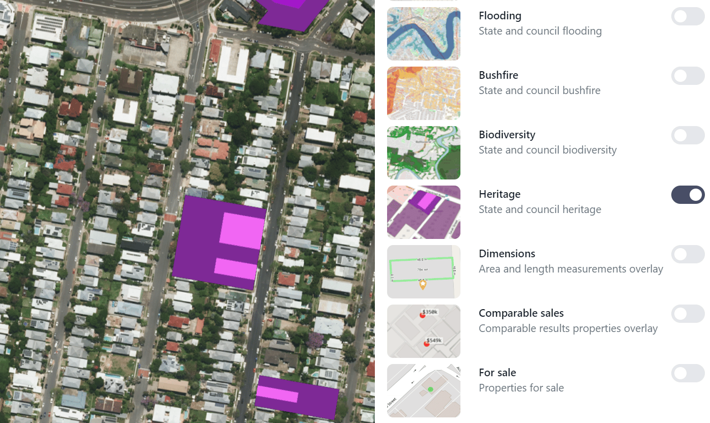
Heritage Overlays. Powered by Stash Property. Click to enlarge image
How to explore Mapping overlays in Stash?
We want you to be aware of all the hazards and limitations that may affect your next property development.
We’ve got you covered! Stash’s map overlays do the searching for you.
To view the Map Overlays inside Stash, check out the steps below:
- Log in to your Stash account.
- Search for the suburb or address you are looking to invest in.
- Click the Layers button on the right-hand side of the map, then under Overlays switch on Flooding, Bushfire, Heritage or Biodiversity. The Street basemap gives the best contrast.
- To check one property, open it and go to the Planning Insights tab. The Risks & Planning Overlays card shows whether each one is detected, with its source and when it was last updated. See Map layers and overlays.
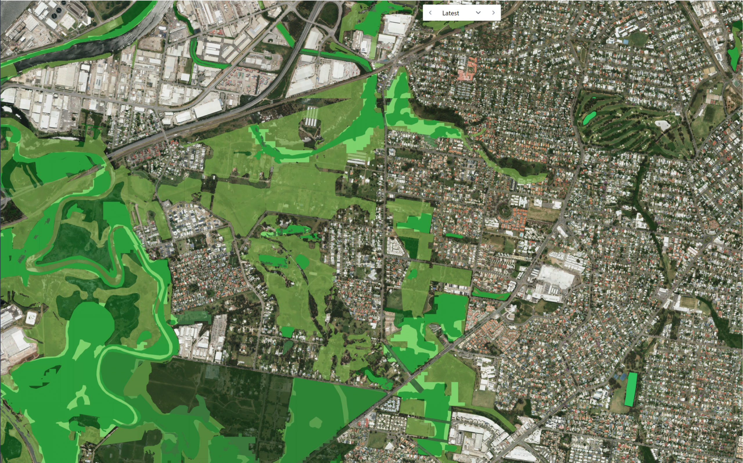
Biodiversity Overlay
Biodiversity datasets are another important resource for developers to consult before making a purchase in Australia. These datasets provide information on the presence of various species and habitats in the area, as well as any conservation efforts that may be in place. Developers should be aware of any protected species or habitats present on the property, as well as any regulations that may be in place to protect them. Stash’s Biodiversity overlay uses state government mapping, plus council mapping in Queensland. For nationally protected species and ecological communities, check the federal EPBC Act Protected Matters Search Tool, which gives an indicative list for any area you draw. See Biodiversity layers.
Flood Maps Overlay
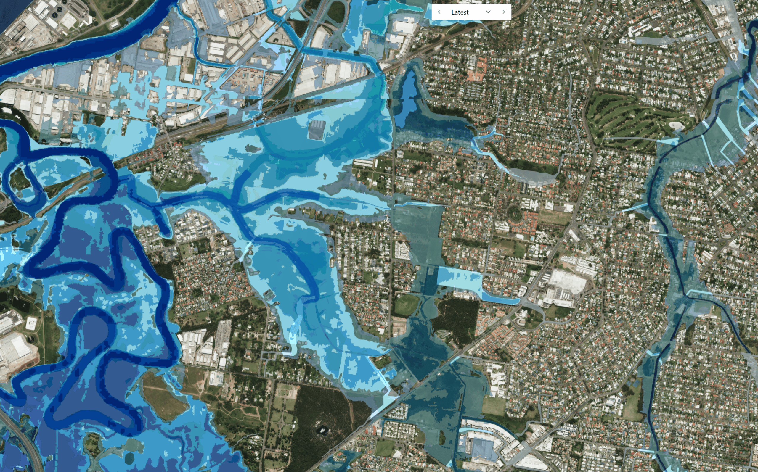
A flood overlay is a planning control that marks land a council or state agency has mapped as at risk of flooding, and it can add development rules such as minimum floor levels. Flood maps are an essential tool for assessing the potential flood risk of a property. These maps show areas that are at high risk of flooding and can help developers identify potential hazards and develop mitigation strategies. Flooding can cause significant damage to a property and its contents, so it’s important to be aware of any potential flood risks before making a purchase. In Australia, flood maps are typically produced by state government agencies and can be accessed through their websites. Councils remain the main source of flood information for their area. In New South Wales, council flood studies and maps are collected in the NSW Flood Data Portal, a joint program of the NSW State Emergency Service and the NSW Government.
Fire Maps Overlay
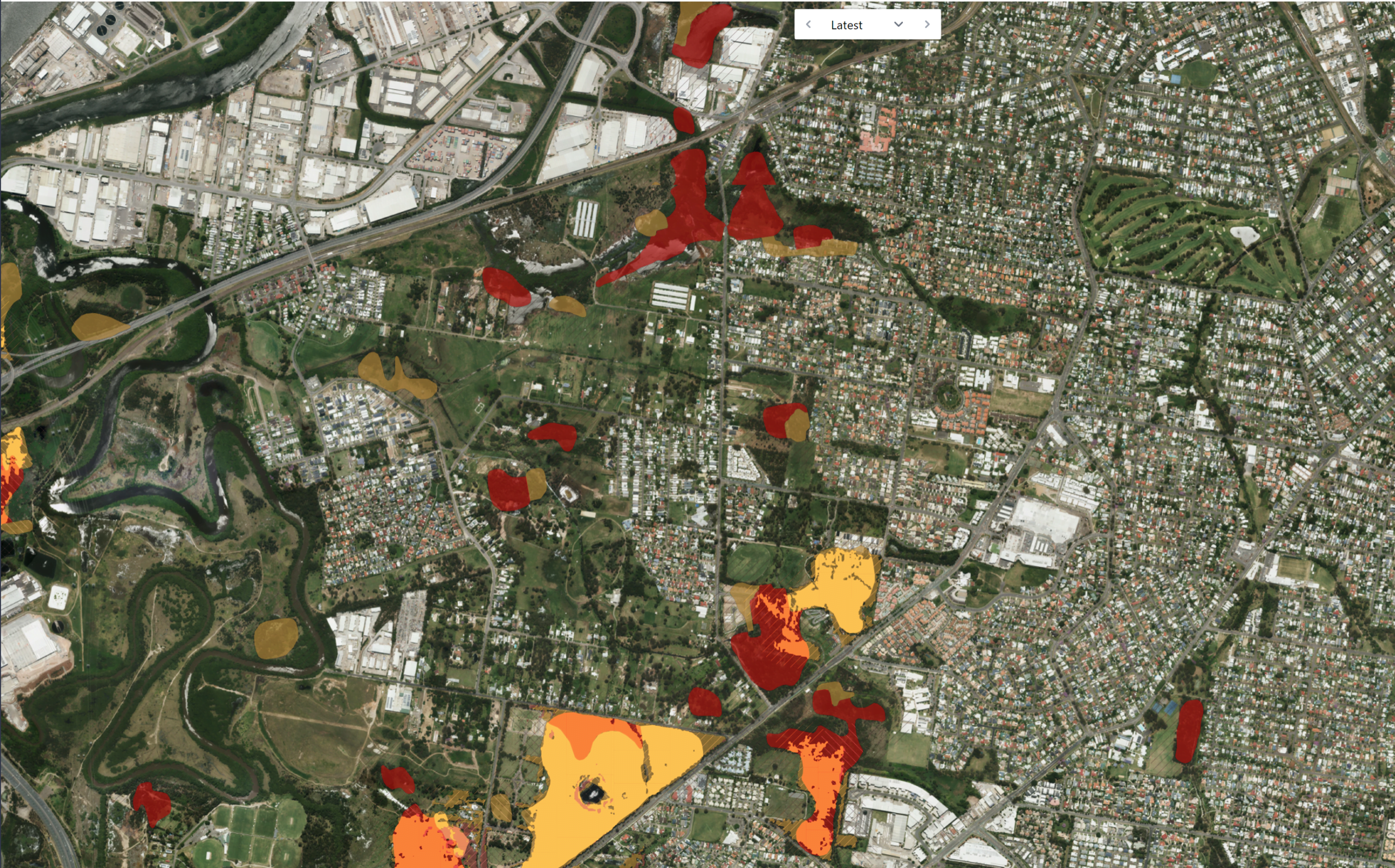
Fire maps are another essential tool for assessing the potential fire risk of a property. These maps show areas that are at high risk of bushfire and can help developers identify potential hazards and develop mitigation strategies. Bushfires can cause significant damage to a property and its surroundings, so it’s important to be aware of any potential fire risks before making a purchase. In Australia, fire maps are typically produced by state and territory agencies responsible for bushfire management such as the New South Wales Rural Fire Service, which has an online tool to check if an address is on bush fire prone land. Bush fire prone land mapping does not give you a Bushfire Attack Level (BAL), which still needs a separate assessment when you build.
Using Stash to check the latest flood maps, fire maps, heritage registers and biodiversity datasets before buying a property for development is crucial. It will help you identify potential risks and obstacles, and plan accordingly.
You should be aware of these restrictions and plan accordingly. By considering these factors, you can gain a more complete understanding of the potential risks and benefits associated with a property, and make a more informed decision about whether or not to buy it.
Overlays are a research tool, and rules change, so confirm the current controls with the council or a town planner before you buy. Ready to try it? Sign up for our free trial and start finding great deals fast!
Happy Stashing!
Not yet a member? Try Stash free today
Existing member? Log in to check out our new maps
Heritage Register Overlay
The heritage register is a list of properties and sites that have been designated as being of historical or cultural significance in Australia. By checking the heritage register, developers can learn more about the history of a property and any potential restrictions that may be in place to protect its historical value. Properties listed in the heritage register often have covenants or other legal agreements in place to protect the building and its surroundings. In Australia, places can be listed at three levels: national and Commonwealth heritage lists, each state’s heritage register, and local heritage items in council planning schemes. For example, in New South Wales, places are listed on the State Heritage Register under the Heritage Act 1977 on the recommendation of the Heritage Council of NSW. Stash’s Heritage overlay uses state registers (all states except the Northern Territory) plus council listings in Queensland, so always check the council’s planning scheme too. See Heritage register layers.
Biodiversity Overlay
Biodiversity datasets are another important resource for developers to consult before making a purchase in Australia. These datasets provide information on the presence of various species and habitats in the area, as well as any conservation efforts that may be in place. Developers should be aware of any protected species or habitats present on the property, as well as any regulations that may be in place to protect them. Stash’s Biodiversity overlay uses state government mapping, plus council mapping in Queensland. For nationally protected species and ecological communities, check the federal EPBC Act Protected Matters Search Tool, which gives an indicative list for any area you draw. See Biodiversity layers.
Flood Maps Overlay
A flood overlay is a planning control that marks land a council or state agency has mapped as at risk of flooding, and it can add development rules such as minimum floor levels. Flood maps are an essential tool for assessing the potential flood risk of a property. These maps show areas that are at high risk of flooding and can help developers identify potential hazards and develop mitigation strategies. Flooding can cause significant damage to a property and its contents, so it’s important to be aware of any potential flood risks before making a purchase. In Australia, flood maps are typically produced by state government agencies and can be accessed through their websites. Councils remain the main source of flood information for their area. In New South Wales, council flood studies and maps are collected in the NSW Flood Data Portal, a joint program of the NSW State Emergency Service and the NSW Government.
Fire Maps Overlay
Fire maps are another essential tool for assessing the potential fire risk of a property. These maps show areas that are at high risk of bushfire and can help developers identify potential hazards and develop mitigation strategies. Bushfires can cause significant damage to a property and its surroundings, so it’s important to be aware of any potential fire risks before making a purchase. In Australia, fire maps are typically produced by state and territory agencies responsible for bushfire management such as the New South Wales Rural Fire Service, which has an online tool to check if an address is on bush fire prone land. Bush fire prone land mapping does not give you a Bushfire Attack Level (BAL), which still needs a separate assessment when you build.
Using Stash to check the latest flood maps, fire maps, heritage registers and biodiversity datasets before buying a property for development is crucial. It will help you identify potential risks and obstacles, and plan accordingly.
You should be aware of these restrictions and plan accordingly. By considering these factors, you can gain a more complete understanding of the potential risks and benefits associated with a property, and make a more informed decision about whether or not to buy it.
Overlays are a research tool, and rules change, so confirm the current controls with the council or a town planner before you buy. Ready to try it? Sign up for our free trial and start finding great deals fast!
Happy Stashing!
Not yet a member? Try Stash free today
Existing member? Log in to check out our new maps
Map Overlays on Stash Property
The 4 Key Map Overlays to check:
Heritage Register Overlay
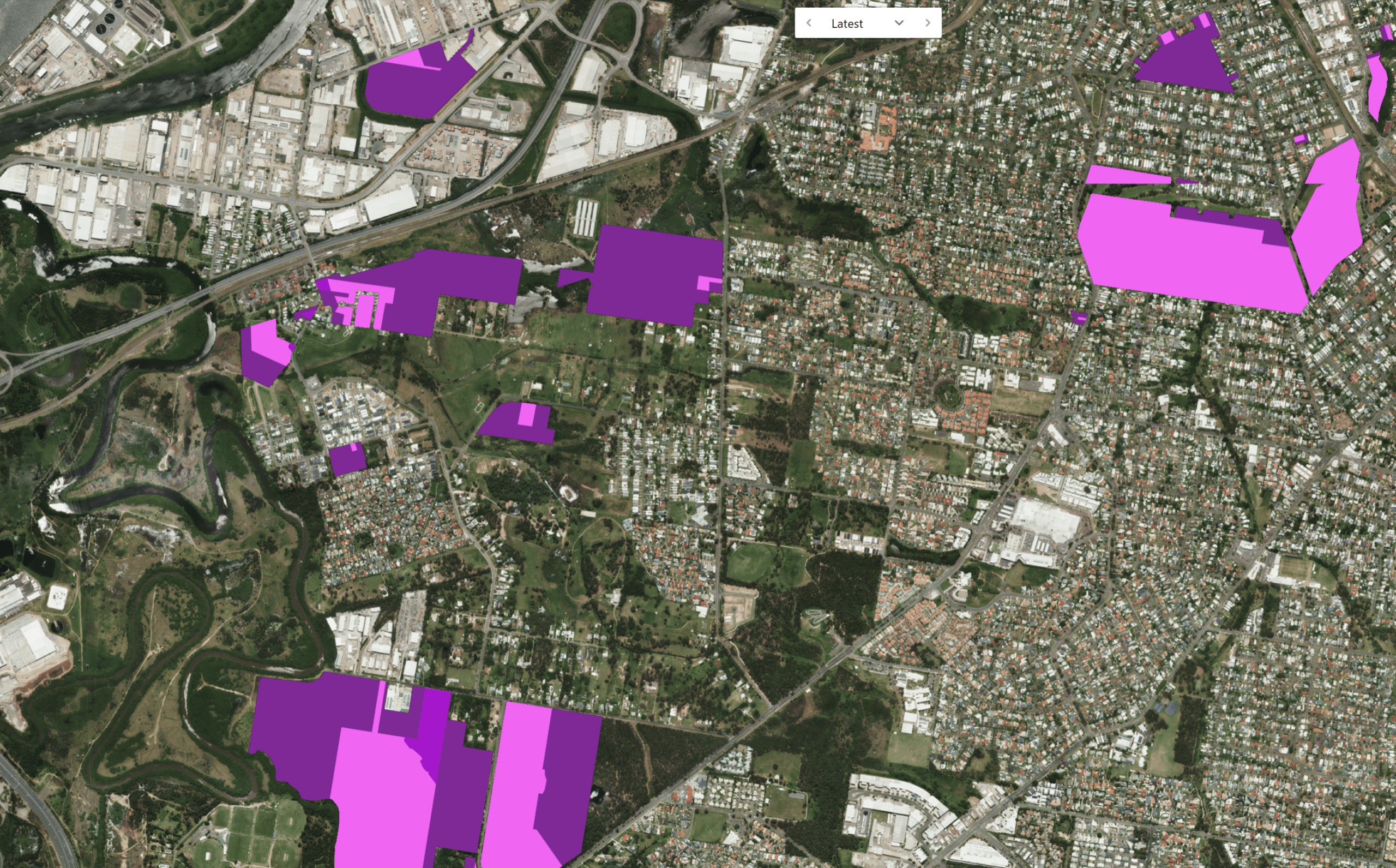
The heritage register is a list of properties and sites that have been designated as being of historical or cultural significance in Australia. By checking the heritage register, developers can learn more about the history of a property and any potential restrictions that may be in place to protect its historical value. Properties listed in the heritage register often have covenants or other legal agreements in place to protect the building and its surroundings. In Australia, places can be listed at three levels: national and Commonwealth heritage lists, each state’s heritage register, and local heritage items in council planning schemes. For example, in New South Wales, places are listed on the State Heritage Register under the Heritage Act 1977 on the recommendation of the Heritage Council of NSW. Stash’s Heritage overlay uses state registers (all states except the Northern Territory) plus council listings in Queensland, so always check the council’s planning scheme too. See Heritage register layers.
Biodiversity Overlay
Biodiversity datasets are another important resource for developers to consult before making a purchase in Australia. These datasets provide information on the presence of various species and habitats in the area, as well as any conservation efforts that may be in place. Developers should be aware of any protected species or habitats present on the property, as well as any regulations that may be in place to protect them. Stash’s Biodiversity overlay uses state government mapping, plus council mapping in Queensland. For nationally protected species and ecological communities, check the federal EPBC Act Protected Matters Search Tool, which gives an indicative list for any area you draw. See Biodiversity layers.
Flood Maps Overlay
A flood overlay is a planning control that marks land a council or state agency has mapped as at risk of flooding, and it can add development rules such as minimum floor levels. Flood maps are an essential tool for assessing the potential flood risk of a property. These maps show areas that are at high risk of flooding and can help developers identify potential hazards and develop mitigation strategies. Flooding can cause significant damage to a property and its contents, so it’s important to be aware of any potential flood risks before making a purchase. In Australia, flood maps are typically produced by state government agencies and can be accessed through their websites. Councils remain the main source of flood information for their area. In New South Wales, council flood studies and maps are collected in the NSW Flood Data Portal, a joint program of the NSW State Emergency Service and the NSW Government.
Fire Maps Overlay
Fire maps are another essential tool for assessing the potential fire risk of a property. These maps show areas that are at high risk of bushfire and can help developers identify potential hazards and develop mitigation strategies. Bushfires can cause significant damage to a property and its surroundings, so it’s important to be aware of any potential fire risks before making a purchase. In Australia, fire maps are typically produced by state and territory agencies responsible for bushfire management such as the New South Wales Rural Fire Service, which has an online tool to check if an address is on bush fire prone land. Bush fire prone land mapping does not give you a Bushfire Attack Level (BAL), which still needs a separate assessment when you build.
Using Stash to check the latest flood maps, fire maps, heritage registers and biodiversity datasets before buying a property for development is crucial. It will help you identify potential risks and obstacles, and plan accordingly.
You should be aware of these restrictions and plan accordingly. By considering these factors, you can gain a more complete understanding of the potential risks and benefits associated with a property, and make a more informed decision about whether or not to buy it.
Overlays are a research tool, and rules change, so confirm the current controls with the council or a town planner before you buy. Ready to try it? Sign up for our free trial and start finding great deals fast!
Happy Stashing!